Murray River Delivery Risks and Shortfalls
Delivering water in the Murray system has always been challenging. Water is released from storages and travels long distances to where it is used along the length of the Murray River. It takes about three weeks to deliver water from Hume Dam to Mildura. “Shortfalls” can occur when river operators aren’t able to deliver water – including to irrigators and the environment – where and when it is needed.
In the Murray River downstream of the Barmah Narrows there has always been a risk of not being able to deliver all the water that water users are entitled to during peak demand periods over summer and autumn. River operators have a strong track record in actively managing the system to deliver water when and where it is needed and avoid a shortfall. However, a shortfall can happen if there is either:
- a heatwave and a sudden spike in demand (a delivery shortfall)
- not enough capacity in the system to supply water to meet all downstream needs throughout summer and autumn (a system shortfall).
Understanding and managing delivery risks together
Victoria is working with the other River Murray states, New South Wales and South Australia, along with the Murray-Darling Basin Authority to better understand delivery risks, including how the risks are changing and how we can collectively manage them. An Independent Panel is overseeing this interstate delivery risks work and has reported that delivery risks are real, and that they will increase in the future.
A joint report, Managing Delivery Risks in the River Murray System, was published in November 2020 that presented key findings from studies investigating delivery risks and the actions needed to support governments and water users to manage them.
Key findings from this report were summarised in a fact sheet to help water users and communities better understand delivery risks in the River Murray System, what has been changing, and the actions needed to help governments and water users respond to these risks.
What's changing in the system
Significant changes across the connected Murray-Darling Basin over the last 10 to 20 years are making it increasingly difficult to deliver water where and when it is needed for irrigation, other consumptive uses, and the environment, without damaging the environmental health of our waterways. These changes include the timing and location of demand for water in the Murray downstream of Barmah, the reduced channel capacity through the Barmah Narrows (sometimes referred to as “the Choke”) and less frequent and variable access to water in the Menindee Lakes.
Climate change will further increase risks due to reduced available water supply options for river operators to call on, and more frequent heatwaves expected to increase spikes in water demands.
A high-level summary of what’s changing in the Murray River is available below:

How governments are responding
To help mitigate increasing delivery risks and minimise the impacts of a potential shortfall, the Victorian government has done the following:
- Introduced the place of take approvals framework to clarify and protect the rights of Victorian water users to have water delivered down rivers and enable more flexibility for water users to manage their own delivery reliability during a shortfall.
- Introduced a cap on Victorian extraction share in the Murray River downstream of Barmah to protect the rights of existing entitlement holders and prevent their rights from being eroded.
- Updated trade rules to ensure that traded water from the Goulburn can be delivered within the ecological tolerances of Victorian rivers without increasing delivery risks.
- Encourages and supports Victorian water users to comply with restrictions in a shortfall, and ensures enforcement actions are applied in an outcome-focussed and proportionate manner.

The Victorian government is also working together with the New South Wales, South Australian and Commonwealth governments and the Murray Darling Basin Authority to manage delivery challenges arising from these system-wide changes by doing the following:
- Reviewing how we run the Murray system to make sure we minimise delivery risks and stay within the ecological tolerances of the system.
- Investigating options to respond to declining capacity of the Barmah Narrows through the Water Delivery Optimisation Program.
- Conducting further investigations to understand this increasing risk.
- Developing shortfall response plans to provide confidence and transparency about the process for how shortfalls are managed. The Victorian Murray Shortfall Response Plan (April 2026) sets out Victoria’s process for managing shortfalls.
Delivery risks – more information
To better understand and manage delivery risks, more information can be found in a series of reports prepared and commissioned jointly by the Murray-Darling Basin Authority (MDBA), Victoria, New South Wales and South Australia. These include:
- Irrigation area mapping of the Murray and Lower Darling rivers (2025)
- An investigation into the location of horticultural water demands (2022)
- Historical flows and water use in the southern connected Murray-Darling Basin (2021)
- Managing Delivery Risks in the River Murray System – What We Heard report (2021)
- Barmah Choke channel capacity and geomorphic investigation (2020)
- Review of historical use of water: Barmah to the South Australian Border (2020)
- Independent Panel on Capacity Risks Report (2019)
For additional information on shortfalls, mitigation measures and the MDBA led River Murray Shortfall Response Plan please visit the MDBA website.
As more information becomes available it will be published on the MDBA’s water demand and shortfalls website.
How water users can prepare for shortfalls
Water users in the Murray downstream of the Barmah Narrows need to be aware that delivery risks are real and that while river operators will do everything they can to avoid shortfalls, there may be occasions where that can’t be done and their water use needs to be restricted.
When shortfalls in the River Murray system cannot be avoided, the water available for delivery is shared between water users in the affected rationing areas, including by water users in NSW and South Australia. This means water use needs to be temporarily restricted to fairly share the impacts of the shortfall.
In Victoria, water users – including irrigators and domestic and stock users – are restricted in proportion to their extraction share (if a river diverter) or in proportion to their delivery share (if in an irrigation district).
The need to restrict water use due to a shortfall has been very rare, however the risk of shortfall is real and increasing. Restrictions to irrigators in the Murray River below Barmah due to a shortfall has only occurred once (in March 2002) when a 10 gigalitre shortfall occurred over a two-week period. This resulted in an average level of restrictions of about 10% being imposed on irrigators.
To manage the impacts of a shortfall, water users may choose to build on farm storage or talk to their water corporation about accessing additional delivery share or extraction share through trading with others within the same rationing area.
What is the risk of Murray River shortfall this season?
During the peak irrigation season the MBDA reports on the current risk of a delivery shortfall in the River Operations Weekly Report.
The Annual Operating Outlook for the River Murray System usually includes commentary on the risk of system shortfall each year. This outlook is published in August and updated in December.
Victorian Murray Shortfall Response Plan
Victoria recognises the importance of having a plan in place to ensure that the response to a shortfall event is coordinated and effective, and limits the impacts on water users and the community.
The first Victorian Murray Shortfall Response Plan was published in 2022 to provide confidence and transparency in the process of managing shortfall events to Victorian water users and the community.
The plan has been updated in 2026 to reflect changes following the introduction of the ‘place of take approvals’ framework in November 2023, and also includes improved processes developed between DEECA, relevant rural water corporations and agencies.
The plan is used by the Victorian Government and agencies within the water sector with a role in the management of shortfall events. As an operational document it is subject to regular updates and will be amended over time.
Murray River shortfalls – more information
DEECA FAQs and fact sheets
DEECA has prepared a fact sheet and FAQ document to help Victorian water users and communities better understand and manage shortfalls in the Murray River downstream of Barmah.
The Murray River delivery risks fact sheet provides a summary of these risks and how they are managed, and informs water users on what a shortfall means for them and how to stay informed.
The Murray Delivery Risks and Shortfalls FAQs explains in more detail what shortfalls are and provides answers to questions related to delivery risks and shortfall events.
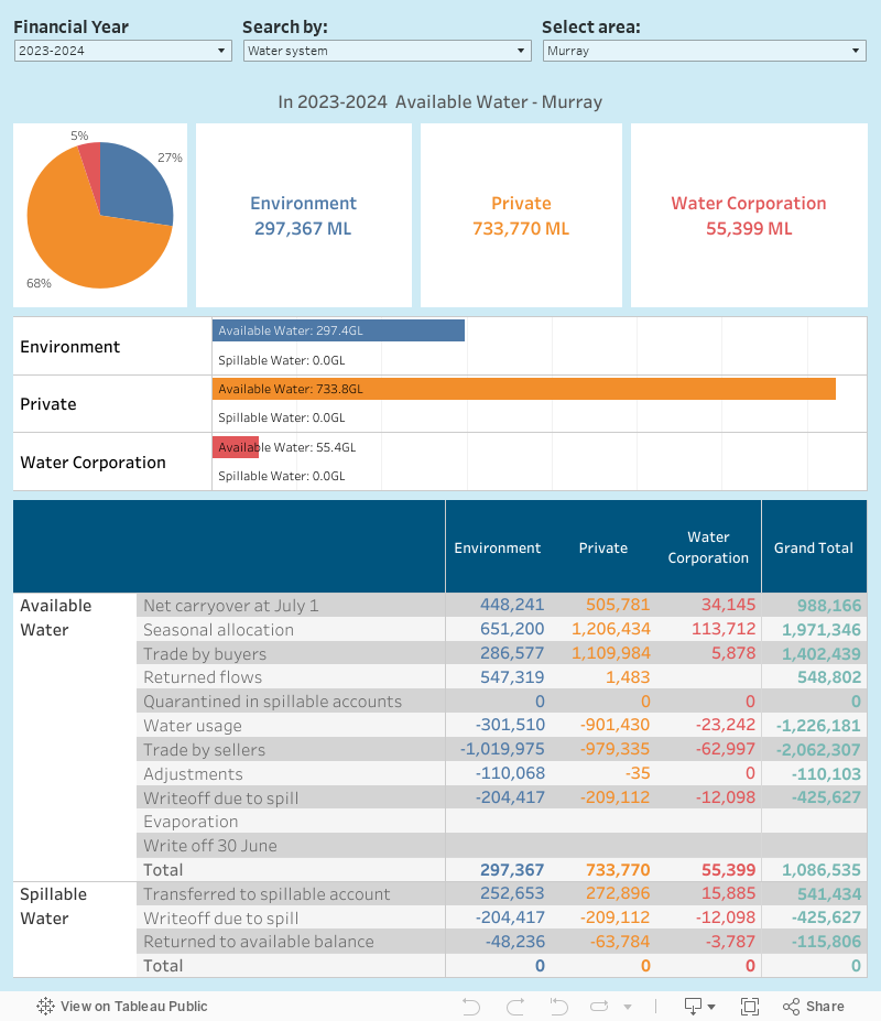
Available water by owner type
This page provides information on the volume of available (or unused) water held by private water holders, environmental water holders or water corporations for a selected regulated water system and year.
Notes and disclaimers This report summarises the water available in a system and how it is split between private water holders, the environment and water corporations. Note that this data includes all allocation accounts with regulated trading zone sources within the selected water system (including water shares and bulk entitlements). If there are issues with this report please click here to let us know.Available water by owner type
In the table:
Further Insights
The following dashboard is an extension on the information above by providing further options on the level of detail for viewing the information on the available water by owner type. This dashboard provides summary information and a supporting detailed breakdown of the available and spillable water.
How do I use the available water by owner type dashboard?
Notes and disclaimers
This report summarises the water available in a system and how it is split between private water holders, the environment and water corporations. Note that this data includes all allocation accounts with regulated trading zone sources within the selected water system (including water shares and bulk entitlements)
In the table:
- Adjustments includes all allocation adjustments made between 2 July and 29 June inclusive. In the Murray trading zones, adjustments may include a positive or negative value representing the movement of water between trading zones to allow for delivery in accordance with provisions of the Bulk Entitlement (River Murray – Flora & Fauna) Conversion Order 1999
- Seasonal allocation includes any spill allocation issued in the Thomson/Macalister and Ovens water systems.
- Write off 30 June excludes allocation carried forward into the next water year.
Water use trends
Diversions of water from rivers and streams in northern Victoria must abide by Murray-Darling Basin caps. These caps are effectively becoming lower as water is recovered for the environment in accordance with the Basin Plan. As shown here, all the systems in Victoria are well under the declining caps.
In many places across northern Victoria water use has decreased over recent years. The millennium drought has meant pressure on irrigation businesses, exacerbated in some industries and places by factors like the high Australian dollar and the January 2012 floods. Many businesses took advantage of government purchasing and modernisation programs to leave irrigation, while those that stayed tended to use water more economically.
Diversions compared with Murray-Darling Basin caps
How diversions from rivers is tracking against Murray-Darling Basin caps is reported in the table and graphs in the document below.
The material here shows that, in 2011/12, the diversion was under the cap target in all valleys. That is, there was a cap credit in each valley. In all valleys there is now an accumulated cap credit which is very high.
Changes in water use
Here is a map showing changes in water use in Goulburn-Murray Water's irrigation districts between 2003/04 and 2011/12.
(This map was compiled by officers from the former Department of Primary Industries using data from the Water Register and other sources.)
2014-15 water entitlements and use report
Summary information about all water entitlements and use recorded in the Victorian Water Register is now available in the report below.
In previous years this information was reported separately in each water corporation's annual report. This new report provides a state-wide overview of this information as well as detail about each individual water corporation's data.
Water use by irrigators, towns & the environment
Summary information on water availability for irrigators, town supplies and the environment in northern Victoria, and how it was used in recent years, is now available in the reports below.
Segmented Available Water
Segmented Available Water
Notes and disclaimers
This report summarises the water available in a system and how it is split between irrigators, the environment and water corporations. Note that this data includes all allocation accounts with regulated trading zone sources within the selected water system (including water shares and bundled entitlements).
In the table:
- Adjustments includes all allocation adjustments made between 2 July and 29 June inclusive, write off adjustments that are greater than 0 ML and overuse transactions
- Seasonal allocation includes any spill allocation issued in the Thomson/Macalister and Ovens water systems.
- Write off 30 June excludes allocation carried forward into the next water year
Water availability and use
You can find information in this part of the site about the amount of water available to entitlement holders and how much has been used.
Seasonal determinations
Allocations to water shares in regulated water systems depend on seasonal determinations of how much water is available.
Unused water
Find out about the total amount of water available in each water system, and how much has been used.
Risk of spill
Find out about the risk of spill in the Murray, Goulburn and Campaspe systems, and any spills advised by the resource manager.
Unregulated surface water
Unregulated waterways are streams or rivers where the flow is not interrupted by dams or weirs, and the volume of water available for diversion is based entirely on rainfall and runoff.
Groundwater
Groundwater refers to water occurring beneath the surface. It is typically accessed by a bore.
About water entitlements
Victoria's water resources are managed under a water entitlement framework which balances demands for water for both consumptive and environmental purposes.
All water taken for consumptive purposes in Victoria is done so under entitlements set out in the Water Act 1989.
Different entitlements are necessary depending on where and how water is taken, and what it is then used for.
Understanding water entitlements
You can learn more about the different types of water entitlements here.
Groundwater
Groundwater refers to water occurring beneath the surface. It is typically accessed by a bore. Accessing groundwater for purposes other than domestic and stock use in Victoria requires a take and use licence, and a works licence to cover bore operation.
To download a Copy of Record for an existing groundwater take-and-use licence, or works licence, click here. A sample Copy of Record of a take-and-use licence can be viewed here.
To generate a report summarising the aquifers and groundwater salinity in any Victorian location visit the Groundwater Resource Reports page on the Department of Energy, Environment and Climate Action website.
Restrictions on entitlement
Use of groundwater resources in a defined management area may be restricted by orders made by the Minister for Water. Permissible Consumptive Volumes (PCVs) cap
Use of groundwater resources in a defined management area may be restricted by orders made by the Minister for Water. Permissible Consumptive Volumes (PCVs) cap the total volume of licensed entitlement in an area, while a temporary qualification of rights restricts a licence holder's right to take water under that licence for a certain period.
To view a PCV order that the Minister has issued, search for PCV at deeca.vic.gov.au for the most recent information.
Victorian Water Accounts
Victoria’s comprehensive approach to knowing and managing water resources is underpinned by monitoring, measurement and reporting of available water through the Victorian Water Accounts (VWA).
DEECA uses data from the Victorian Water Register and other sources to produce the VWA. The VWA provides a year-by-year overview of water availability and use across Victoria at a bulk supply level. This includes a detailed water account for each of Victoria's 29 river basins and 20 groundwater catchments.
Now in its 21st year, the report is available on the VWA website. The 2023–24 VWA saw dry conditions across much of southern and western Victoria following 2 years of above average rainfall. Total water use volumes were roughly 15% higher than the previous year.
The VWA’s information is a critical input to enabling water corporations and the Victorian Government to plan for climate change and a lower water availability future due though Annual Water Outlooks, Urban Water Strategies and the development of Victoria’s Water Security Plan and its detailed investigations.
VWAs for earlier years going back to 2003-04 remain available as PDFs on the VWA’s previous accounts webpage. For more reporting resources, please visit Water monitoring and reporting.
Preparation of the 2024–25 VWA is now underway, for release in 2026. Contact the water reporting team if you have any queries about the 2023–24 VWA, or if you wish to be notified when we release the next VWA.
Unregulated surface water
Unregulated waterways are streams or rivers where the flow is not interrupted by dams or weirs, and the volume of water available for diversion is based entirely on rainfall and runoff.
Accessing water for irrigation from unregulated waterways in Victoria requires a take and use licence, and may require a works licence.
Determining what is a waterway can be difficult, but is important because it has implications for licensing requirements. All dams on waterways require a section 67 works licence (except in some cases where an exemption order applies). A ‘waterway’ is defined in the Water Act 1989. The Minister for Water has endorsed guidelines to promote the consistent application of the definition.
Copies of records for an existing groundwater or unregulated waterway take-and-use licence, or works licence can be obtained from here.
Restrictions on entitlement
Surface water resources may be restricted by orders made by the Minister for Water. Permissible Consumptive Volumes (PCVs) cap the total volume of licensed entitlement in a river basin. To view the orders that the Minister has issued, search for PCV at deeca.vic.gov.au for the most recent information.